
Allan Behm
In case anyone thinks that Indonesia’s somewhat diffident assertion of its fishing rights in the waters around the Natuna Islands in the South China Sea is just the usual squabble between fishermen from neighbouring countries, it’s important to recognise the issue for what it is: another potential trigger for serious force escalation in the South China Sea. And in case anyone thinks that China is going to back down and let Indonesian patrol vessels open fire on Chinese fishing vessels and then arrest them, it’s important to recognise that capitulation is about the last thing that China would contemplate.
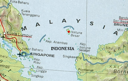
First, a bit of geography. The Natuna archipelago consists of 272 islands with the largest, Natuna Besar, lying approximately 600 kilometres east of Kuantan (Malaysia) and 150 kilometres north-west of the northernmost tip of Kalimantan and almost 2,000 kilometers south of Hainan. Indonesia’s maritime border extends approximately 20 kilometers north of the most northern island of the group, Pulau Laut. Indonesia’s maritime border is recognised by Singapore, Malaysia and the Philippines, and there are no maritime issues in contention between them.
Second, a bit of geopolitics. China’s ‘nine dash line’, on which it stakes its South China Sea claims, was initially a Taiwanese claim, manufactured in 1947 with the assistance of the US. It includes the Paracel Islands to the east of Vietnam, Scarborough Reef to the west of the Philippines and the Spratly Islands to the west of the Philippines and north-west of Sabah. Malaysia, Brunei and the Philippines have conflicting claims to parts of the Spratley Islands, while China, Taiwan and Vietnam claim the lot. The problem for Indonesia, and China for that matter, is that the ‘nine dash line’ is not continuous, and just how the sixth and seventh dashes might be linked is part of the issue. But not all of it.